


To Be, or Not to Be? That is the Question for Diego Garcia
Add the base in the Chagos Islands to the Greenland and Panama Canal security issues, eh?

Surrendering UK sovereignty of the Chagos Islands is an “irresponsible act”, a Labour former minister has said, backing calls for the Government to withdraw from a deal over the territory.
Admiral Lord West of Spithead, formerly the first sea lord, said it was “difficult to fathom” why the UK was jeopardising its strategically important military base on Diego Garcia, as well as its relationship with the US over the deal. …
He added: “For reasons that are difficult to fathom, the Government risks jeopardising both of these assets as it apparently remains determined to cede sovereignty of the Chagos Islands – the home of our vital Diego Garcia military base – to Mauritius.
Perhaps the British also believe they will get more American support to retain control of the island.
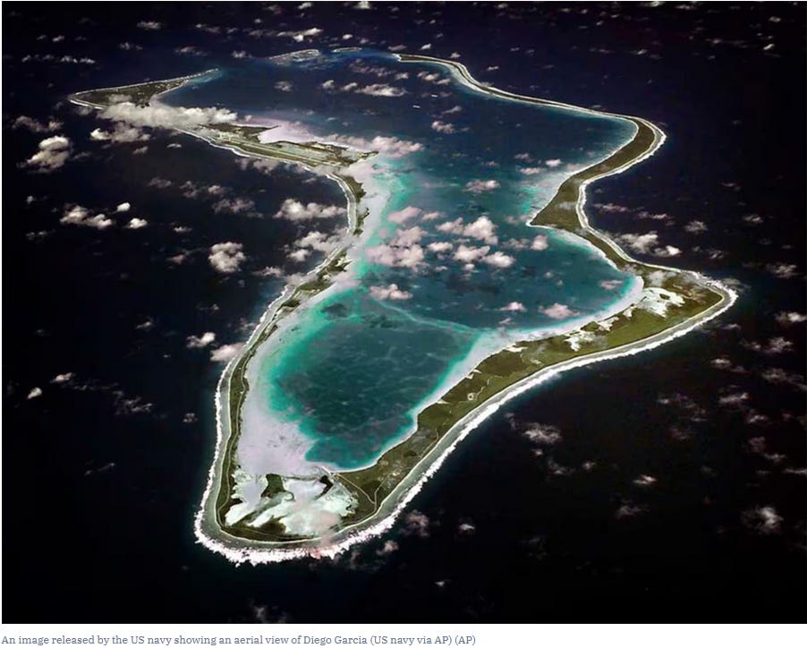
The atoll of Diego Garcia is in the Chagos Islands located on a large shoal area known as the Great Chagos Bank. Diego Garcia is the largest of 55 islands that form the Chagos Archipelago within the British Indian Ocean Territory (BIOT) and is known as the "Footprint of Freedom" for its shape, regional location, and strategic importance. The island is located seven degrees south of the equator very close to the geographic center of the Indian Ocean. Diego Garica was discovered by Portuguese explorers in the early sixteenth century and its name is believed to have come from either an early explorer's ship captain or its navigator. Under the Treaty of Paris of 1814, many of the islands in the Indian Ocean under the control of the French were ceded to Britain, including the Mauritius and the Chagos Islands. In 1965, these islands became the British Indian Ocean Territory (B.I.O.T.). During the 19th Century, the islands were used as plantations, producing copra and coconut oils. Plantations on Diego Garcia were closed in 1971, following a decision to establish the U.S. Navy Support Facility based on the 1966 Exchange of Notes between Great Britain and the United States. In January 1971, U.S. Navy Seabees were transported to the island by landing ship to begin building the U.S. military presence on Diego Garcia. Today Diego Garcia is home to 15 separate commands, including the U.S. Navy Support Facility, which functions as the host command.
The island stretches about 38 miles tip to tip and has an average elevation of four feet above sea level with a maximum elevation of 22 feet. The lagoon varies in depth from 10 to 100 feet. This lush, tropical island is home to an international population consisting primarily of Filipino and Mauritian contractors, and British and U.S. military.
The U.S. Navy is the primary American service there:
U.S. Navy Support Facility Diego Garcia provides logistic support to operational forces forward deployed to the Indian Ocean and Persian Gulf areas of responsibility in support of national policy objectives.
Military Prepositioning Ships Squadron 2 is based there:
These time-chartered ships carry afloat prepositioned U.S. military cargo for the U.S. Marine Corps and the U.S. Army. The Squadron's mission is to provide sea transportation of vital equipment and supplies to a designated area of operations.
MPSRON 2 also has operational control of Combat Prepositioning Force and Logistics Prepositioning Ships. Combat Prepositioning Force ships provide quick-response delivery of U.S. Army equipment for ground troops. Logistics Prepositioning Ships do the same for the U.S. Air Force, the U.S. Navy and the Defense Logistics Agency.
The defense of Greenland and the Panama Canal, as well as the state of Canada’s military to guard its Arctic frontier, have been raised as vital American national security issues. Diego Garcia should be added to the list of outposts that don’t get enough attention for their importance. We should support efforts by Britain to retain control of the vital atoll.